

Version: 2021-5. Current as of 22 September 2021.
Download this page as PDF. See related articles.
 Queensland’s Nature Conservation Act 1992 (NC Act) requires the protection of certain native plants.
A protected plant trigger map indicates critically-endangered, vulnerable or near-threatened (EVNT) native plants may exist on your property.
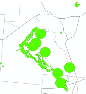
Protected EVNT plants are lime green circles or squiggles on the protected plant trigger map. The circles are 2km buffers around the location of a recorded EVNT plant species.
Since June 2019, revised trigger maps released by the Queensland Department of Environment and Science also include highly suitable habitat for endangered plant species (squiggles) in category A,B,C or R regulated vegetation and wetlands.
Request a map from the Queensland Government. Maps are updated annually.
Protected plants can occur in Category A, B, C, R regulated native vegetation and Category X non-remnant vegetation, even if you have a Property Map of Assessable Vegetation PMAV in place.
Before conducting any vegetation management activities within a trigger area you may require the services of a suitably qualified person to prepare a flora survey and obtain a clearing protected plant permit, unless an exemption applies.
Exemptions on agricultural land include:
- routine maintenance of existing infrastructure such as roads, fences and buildings or ongoing cropping activity.
- establishing or maintaining a firebreak or fire management line.
- clearing complies with accepted development vegetation clearing codes for weeds and encroachment.
- removal of plants or plant parts to reduce imminent risk of serious injury to persons or imminent risk of damage to buildings.
- re-clearing within 10 years, where the initial clearing was legally conducted under a protected plant clearing permit issued under the NC Act or following a flora survey.
What EVNT plant species are present?
The protected plant trigger map does not identify the plant species. Information on EVNT plant species can be obtained from using Biomaps or Queensland Globe, with the ‘WildNet’ layer turned on.
An environmental report, including a ‘conservation significant species list of plants and animals’ for a Lot on Plan location can be obtained from here.
Queensland Government’s WildNet database provides a free web-based search of threatened and near-threatened species within a specified radius of a central coordinate or specified corners of an area of interest. Reports are available here. Coordinates must be in decimal degrees (example shown on the request form), you can determine these using either Queensland Globe or Google Earth. Ensure you select ‘native’ and ‘threatened and near-threatened status’ in the list of report data options. A PDF report will be emailed to you.
To see photos of the EVNT plant species listed in your report, use the Australasian Virtual Herbarium. Contact AgForce if you require further details on how to search these free, online herbarium records to find out what EVNT protected plant species may be present on your property.
Frequently asked questions
What if no exemptions apply and the flora survey finds there are EVNT species present in the area I want to clear?
If the flora survey shows an EVNT species is present, then a clearing permit will be required before clearing can occur. Protected plants clearing permits are issued by the Queensland Department of Environment and Science.
What if your property is not covered by a lime-green dot, but you are aware of the presence of an EVNT species?
If the entire area to be cleared is shown as white on the flora survey trigger map, but you are aware there are critically-endangered, vulnerable or near-threatened plants within the area to be cleared (or clearing would occur within 100m of the EVNT plant), then a clearing permit will be required before clearing can occur.
Can I amend a high-risk area on a flora trigger map?
You can request the Department of Environment and Science amends the trigger map up to a period of ten years if:
- a flora survey was conducted by a suitably qualified person within the last 12 months, and
- no EVNT plants occur within 100m of the area.
Amending a trigger map is not an authority to clear protected plants in the area.
More information
- Request a map.
- Queensland Department of Environment and Science - Protected Plants - Phone 13 QGOV (13 74 68)
- Related AgForce resources.